
Magnitude 4.8 - VANUATU
This webpage has been replaced by a new version and will be phased out in the future. Please use our new Real-time Earthquake Map to access the latest earthquake information and event details. The links to the World, US, and CA/NV maps that were in the navigation on the left side of the page have been replaced by the links at the top of the new Map. The Real-time Earthquake Map User Guide describes how to use the map and all its features.
2012 May 08 00:32:56 UTC
Earthquake Details
- This event has been reviewed by a seismologist.
| Magnitude | 4.8 |
|---|---|
| Date-Time |
|
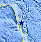
| Location | 14.421°S, 167.172°E |
| Depth | 169.6 km (105.4 miles) |
| Region | VANUATU |
| Distances | 123 km (76 miles) N of Luganville, Espiritu Santo, Vanuatu 386 km (239 miles) NNW of PORT-VILA, Efate, Vanuatu 434 km (269 miles) SSE of Lata, Santa Cruz Islands, Solomon Isl. 2061 km (1280 miles) NE of BRISBANE, Queensland, Australia |
| Location Uncertainty | horizontal +/- 15.9 km (9.9 miles); depth +/- 7.2 km (4.5 miles) |
| Parameters | NST=133, Nph=140, Dmin=850.5 km, Rmss=0.79 sec, Gp= 54°, M-type=body wave magnitude (Mb), Version=7 |
| Source |
|
| Event ID | usb0009k8d |
- Did you feel it? Report shaking and damage at your location. You can also view a map displaying accumulated data from your report and others.
Earthquake Maps


Scientific & Technical Information
 Historic Moment Tensor Solutions
- Preliminary Earthquake Report
- U.S. Geological Survey, National Earthquake Information Center:
World Data Center for Seismology, Denver
