
Magnitude 6.0 - VANUATU
2012 February 05 16:40:39 UTC
Earthquake Details
- This event has been reviewed by a seismologist.
| Magnitude | 6.0 |
|---|---|
| Date-Time |
|
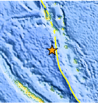
| Location | 17.952°S, 167.230°E |
| Depth | 10.3 km (6.4 miles) |
| Region | VANUATU |
| Distances | 123 km (76 miles) WSW of PORT-VILA, Efate, Vanuatu 267 km (165 miles) S of Luganville, Espiritu Santo, Vanuatu 283 km (175 miles) NW of Isangel, Tanna, Vanuatu 1795 km (1115 miles) ENE of BRISBANE, Queensland, Australia |
| Location Uncertainty | horizontal +/- 14.3 km (8.9 miles); depth +/- 4.5 km (2.8 miles) |
| Parameters | NST=423, Nph=427, Dmin=463.1 km, Rmss=0.75 sec, Gp= 18°, M-type=teleseismic moment magnitude (Mw), Version=B |
| Source |
|
| Event ID | usb0007w87 |
- Did you feel it? Report shaking and damage at your location. You can also view a map displaying accumulated data from your report and others.
Earthquake Maps


Scientific & Technical Information

 Tsunami Information
The earthquake locations and magnitudes cited in NOAA tsunami statements and bulletins are preliminary and are superseded by USGS locations and magnitudes computed using more extensive data sets.
General Tsunami Information
- Preliminary Earthquake Report
- U.S. Geological Survey, National Earthquake Information Center:
World Data Center for Seismology, Denver
