
Magnitude 4.7 - TONGA
2011 November 09 13:49:21 UTC
Earthquake Details
- This event has been reviewed by a seismologist.
| Magnitude | 4.7 |
|---|---|
| Date-Time |
|
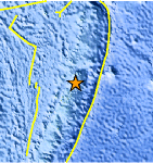
| Location | 19.147°S, 174.067°W |
| Depth | 10 km (6.2 miles) set by location program |
| Region | TONGA |
| Distances | 58 km (36 miles) SSW of Neiafu, Tonga 246 km (152 miles) NNE of NUKU`ALOFA, Tonga 358 km (222 miles) S of Hihifo, Tonga 2243 km (1393 miles) NNE of Auckland, New Zealand |
| Location Uncertainty | horizontal +/- 15.8 km (9.8 miles); depth fixed by location program |
| Parameters | NST= 29, Nph= 29, Dmin=629.2 km, Rmss=1.04 sec, Gp=144°, M-type=body wave magnitude (Mb), Version=A |
| Source |
|
| Event ID | usb0006mfb |
- Did you feel it? Report shaking and damage at your location. You can also view a map displaying accumulated data from your report and others.
Earthquake Maps


Scientific & Technical Information
 Historic Moment Tensor Solutions
- Preliminary Earthquake Report
- U.S. Geological Survey, National Earthquake Information Center:
World Data Center for Seismology, Denver
