
Magnitude 4.8 - BANDA SEA
2011 November 09 11:23:26 UTC
Earthquake Details
- This event has been reviewed by a seismologist.
| Magnitude | 4.8 |
|---|---|
| Date-Time |
|
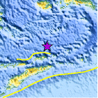
| Location | 6.831°S, 126.856°E |
| Depth | 440.2 km (273.5 miles) |
| Region | BANDA SEA |
| Distances | 238 km (147 miles) NE of DILI, Timor-Leste 376 km (233 miles) SSW of Ambon, Moluccas, Indonesia 495 km (307 miles) ESE of Baubau, Sulawesi, Indonesia 761 km (472 miles) NW of DARWIN, Northern Territory, Australia |
| Location Uncertainty | horizontal +/- 16.8 km (10.4 miles); depth +/- 12.8 km (8.0 miles) |
| Parameters | NST= 35, Nph= 37, Dmin=430.8 km, Rmss=0.66 sec, Gp= 61°, M-type=body wave magnitude (Mb), Version=5 |
| Source |
|
| Event ID | usb0006me4 |
- Did you feel it? Report shaking and damage at your location. You can also view a map displaying accumulated data from your report and others.

Earthquake Maps


Scientific & Technical Information
 Historic Moment Tensor Solutions
- Preliminary Earthquake Report
- U.S. Geological Survey, National Earthquake Information Center:
World Data Center for Seismology, Denver
