
Magnitude 4.4 - SOUTH OF THE FIJI ISLANDS
2011 November 08 12:36:15 UTC
Earthquake Details
- This event has been reviewed by a seismologist.
| Magnitude | 4.4 |
|---|---|
| Date-Time |
|
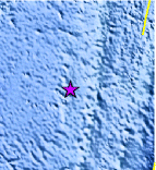
| Location | 25.301°S, 179.634°E |
| Depth | 498.1 km (309.5 miles) |
| Region | SOUTH OF THE FIJI ISLANDS |
| Distances | 502 km (311 miles) NNW of Raoul Island, Kermadec Islands 542 km (336 miles) SSW of Ndoi Island, Fiji 701 km (435 miles) SW of NUKU`ALOFA, Tonga 1363 km (846 miles) NNE of Auckland, New Zealand |
| Location Uncertainty | horizontal +/- 23.6 km (14.7 miles); depth +/- 14.4 km (8.9 miles) |
| Parameters | NST= 56, Nph= 56, Dmin=499.8 km, Rmss=0.63 sec, Gp= 94°, M-type=body wave magnitude (Mb), Version=6 |
| Source |
|
| Event ID | usb0006lvj |
- Did you feel it? Report shaking and damage at your location. You can also view a map displaying accumulated data from your report and others.
Earthquake Maps


Scientific & Technical Information
 Historic Moment Tensor Solutions
- Preliminary Earthquake Report
- U.S. Geological Survey, National Earthquake Information Center:
World Data Center for Seismology, Denver
