
Magnitude 4.6 - BALI SEA
2011 November 07 22:04:28 UTC
Earthquake Details
- This event has been reviewed by a seismologist.
| Magnitude | 4.6 |
|---|---|
| Date-Time |
|
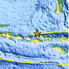
| Location | 7.938°S, 117.327°E |
| Depth | 11.7 km (7.3 miles) |
| Region | BALI SEA |
| Distances | 151 km (93 miles) ENE of Mataram, Lombok, Indonesia 163 km (101 miles) WNW of Bima, Sumbawa, Indonesia 910 km (565 miles) W of DILI, Timor-Leste 1176 km (730 miles) E of JAKARTA, Java, Indonesia |
| Location Uncertainty | horizontal +/- 21.4 km (13.3 miles); depth +/- 9.7 km (6.0 miles) |
| Parameters | NST= 26, Nph= 26, Dmin=355.1 km, Rmss=1.12 sec, Gp= 76°, M-type=body wave magnitude (Mb), Version=4 |
| Source |
|
| Event ID | usb0006lfs |
- Did you feel it? Report shaking and damage at your location. You can also view a map displaying accumulated data from your report and others.

Earthquake Maps


Scientific & Technical Information
 Historic Moment Tensor Solutions
- Preliminary Earthquake Report
- U.S. Geological Survey, National Earthquake Information Center:
World Data Center for Seismology, Denver
