
Magnitude 4.7 - BISMARCK SEA
2011 November 07 02:28:08 UTC
Earthquake Details
- This event has been reviewed by a seismologist.
| Magnitude | 4.7 |
|---|---|
| Date-Time |
|
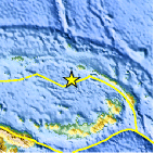
| Location | 3.217°S, 149.718°E |
| Depth | 35 km (21.7 miles) |
| Region | BISMARCK SEA |
| Distances | 140 km (86 miles) WSW of Kavieng, New Ireland, PNG 262 km (162 miles) N of Kimbe, New Britain, PNG 745 km (462 miles) NNE of PORT MORESBY, Papua New Guinea 2710 km (1683 miles) N of BRISBANE, Queensland, Australia |
| Location Uncertainty | horizontal +/- 21.9 km (13.6 miles); depth +/- 4.4 km (2.7 miles) |
| Parameters | NST= 16, Nph= 17, Dmin=292.8 km, Rmss=0.41 sec, Gp= 90°, M-type=body wave magnitude (Mb), Version=3 |
| Source |
|
| Event ID | usb0006l1e |
- Did you feel it? Report shaking and damage at your location. You can also view a map displaying accumulated data from your report and others.

Earthquake Maps


Scientific & Technical Information
 Historic Moment Tensor Solutions
- Preliminary Earthquake Report
- U.S. Geological Survey, National Earthquake Information Center:
World Data Center for Seismology, Denver
