
Magnitude 4.6 - TONGA REGION
2011 November 06 08:31:28 UTC
Earthquake Details
- This event has been reviewed by a seismologist.
| Magnitude | 4.6 |
|---|---|
| Date-Time |
|
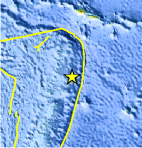
| Location | 17.238°S, 172.971°W |
| Depth | 34.8 km (21.6 miles) |
| Region | TONGA REGION |
| Distances | 165 km (102 miles) SSE of Hihifo, Tonga 189 km (117 miles) NE of Neiafu, Tonga 399 km (247 miles) SSW of APIA, Samoa 2487 km (1545 miles) NNE of Auckland, New Zealand |
| Location Uncertainty | horizontal +/- 28.2 km (17.5 miles); depth +/- 3.3 km (2.1 miles) |
| Parameters | NST= 44, Nph= 44, Dmin=>999 km, Rmss=0.59 sec, Gp=122°, M-type=body wave magnitude (Mb), Version=7 |
| Source |
|
| Event ID | usb0006kq9 |
- Did you feel it? Report shaking and damage at your location. You can also view a map displaying accumulated data from your report and others.
Earthquake Maps


Scientific & Technical Information
 Historic Moment Tensor Solutions
- Preliminary Earthquake Report
- U.S. Geological Survey, National Earthquake Information Center:
World Data Center for Seismology, Denver
