
Magnitude 4.9 - FIJI REGION
2011 November 06 04:00:05 UTC
Earthquake Details
- This event has been reviewed by a seismologist.
| Magnitude | 4.9 |
|---|---|
| Date-Time |
|
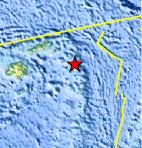
| Location | 17.551°S, 178.783°W |
| Depth | 533.8 km (331.7 miles) |
| Region | FIJI REGION |
| Distances | 232 km (144 miles) ESE of Lambasa, Vanua Levu, Fiji 304 km (188 miles) ENE of SUVA, Viti Levu, Fiji 343 km (213 miles) N of Ndoi Island, Fiji 2232 km (1386 miles) NNE of Auckland, New Zealand |
| Location Uncertainty | horizontal +/- 18.5 km (11.5 miles); depth +/- 9.3 km (5.8 miles) |
| Parameters | NST=110, Nph=113, Dmin=336.2 km, Rmss=1 sec, Gp= 65°, M-type=body wave magnitude (Mb), Version=4 |
| Source |
|
| Event ID | usb0006kmp |
- Did you feel it? Report shaking and damage at your location. You can also view a map displaying accumulated data from your report and others.
Earthquake Maps


Scientific & Technical Information
 Historic Moment Tensor Solutions
- Preliminary Earthquake Report
- U.S. Geological Survey, National Earthquake Information Center:
World Data Center for Seismology, Denver
