
Magnitude 4.9 - MORO GULF, MINDANAO, PHILIPPINES
2011 November 05 23:28:01 UTC
Earthquake Details
- This event has been reviewed by a seismologist.
| Magnitude | 4.9 |
|---|---|
| Date-Time |
|
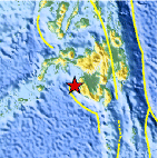
| Location | 6.680°N, 123.784°E |
| Depth | 562.5 km (349.5 miles) |
| Region | MORO GULF, MINDANAO, PHILIPPINES |
| Distances | 79 km (49 miles) SW of Cotabato, Mindanao, Philippines 130 km (80 miles) SSE of Pagadian, Mindanao, Philippines 166 km (103 miles) WNW of General Santos, Mindanao, Philippines 928 km (576 miles) SSE of MANILA, Philippines |
| Location Uncertainty | horizontal +/- 16.7 km (10.4 miles); depth +/- 2.1 km (1.3 miles) |
| Parameters | NST= 77, Nph= 84, Dmin=202.6 km, Rmss=0.43 sec, Gp= 47°, M-type=body wave magnitude (Mb), Version=6 |
| Source |
|
| Event ID | usb0006kkk |
- Did you feel it? Report shaking and damage at your location. You can also view a map displaying accumulated data from your report and others.

Earthquake Maps


Scientific & Technical Information
 Historic Moment Tensor Solutions
- Preliminary Earthquake Report
- U.S. Geological Survey, National Earthquake Information Center:
World Data Center for Seismology, Denver
