
Magnitude 4.8 - PAPUA, INDONESIA
2011 November 05 12:09:44 UTC
Earthquake Details
- This event has been reviewed by a seismologist.
| Magnitude | 4.8 |
|---|---|
| Date-Time |
|
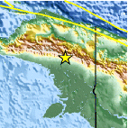
| Location | 4.609°S, 139.105°E |
| Depth | 43.8 km (27.2 miles) |
| Region | PAPUA, INDONESIA |
| Distances | 209 km (129 miles) NW of Tanahmerah, Papua, Indonesia 290 km (180 miles) SW of Jayapura, Papua, Indonesia 1258 km (781 miles) NE of DARWIN, Northern Territory, Australia 3580 km (2224 miles) E of JAKARTA, Java, Indonesia |
| Location Uncertainty | horizontal +/- 18.9 km (11.7 miles); depth +/- 11.7 km (7.3 miles) |
| Parameters | NST= 39, Nph= 41, Dmin=783.7 km, Rmss=0.82 sec, Gp= 97°, M-type=body wave magnitude (Mb), Version=7 |
| Source |
|
| Event ID | usb0006kd1 |
- Did you feel it? Report shaking and damage at your location. You can also view a map displaying accumulated data from your report and others.

Earthquake Maps


Scientific & Technical Information
 Historic Moment Tensor Solutions
- Preliminary Earthquake Report
- U.S. Geological Survey, National Earthquake Information Center:
World Data Center for Seismology, Denver
