
Magnitude 4.8 - COOK STRAIT, NEW ZEALAND
2011 November 01 22:41:58 UTC
Earthquake Details
- This event has been reviewed by a seismologist.
| Magnitude | 4.8 |
|---|---|
| Date-Time |
|
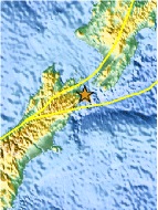
| Location | 41.731°S, 174.290°E |
| Depth | 14.5 km (9.0 miles) |
| Region | COOK STRAIT, NEW ZEALAND |
| Distances | 63 km (39 miles) SW of WELLINGTON, New Zealand 189 km (117 miles) SW of Palmerston North, New Zealand 223 km (138 miles) E of Westport, New Zealand 242 km (150 miles) NE of Christchurch, New Zealand |
| Location Uncertainty | horizontal +/- 14.3 km (8.9 miles); depth +/- 9.6 km (6.0 miles) |
| Parameters | NST= 26, Nph= 26, Dmin=57.9 km, Rmss=1.19 sec, Gp=126°, M-type=body wave magnitude (Mb), Version=5 |
| Source |
|
| Event ID | usb0006hux |
- Did you feel it? Report shaking and damage at your location. You can also view a map displaying accumulated data from your report and others.

Earthquake Maps


Scientific & Technical Information
 Historic Moment Tensor Solutions
Additional Information
- Preliminary Earthquake Report
- U.S. Geological Survey, National Earthquake Information Center:
World Data Center for Seismology, Denver
