
Magnitude 4.7 - NORTHERN SUMATRA, INDONESIA
2011 November 01 22:02:13 UTC
Earthquake Details
- This event has been reviewed by a seismologist.
| Magnitude | 4.7 |
|---|---|
| Date-Time |
|
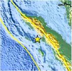
| Location | 2.551°N, 97.151°E |
| Depth | 45.9 km (28.5 miles) |
| Region | NORTHERN SUMATRA, INDONESIA |
| Distances | 201 km (124 miles) WNW of Sibolga, Sumatra, Indonesia 203 km (126 miles) SW of Medan, Sumatra, Indonesia 510 km (316 miles) W of KUALA LUMPUR, Malaysia 1445 km (897 miles) NW of JAKARTA, Java, Indonesia |
| Location Uncertainty | horizontal +/- 26.2 km (16.3 miles); depth +/- 11 km (6.8 miles) |
| Parameters | NST= 39, Nph= 40, Dmin=198.1 km, Rmss=0.95 sec, Gp=173°, M-type=body wave magnitude (Mb), Version=5 |
| Source |
|
| Event ID | usb0006htk |
- Did you feel it? Report shaking and damage at your location. You can also view a map displaying accumulated data from your report and others.

Earthquake Maps


Scientific & Technical Information
 Historic Moment Tensor Solutions
- Preliminary Earthquake Report
- U.S. Geological Survey, National Earthquake Information Center:
World Data Center for Seismology, Denver
