
Magnitude 4.8 - SOUTH OF JAVA, INDONESIA
2011 October 31 04:48:44 UTC
Earthquake Details
- This event has been reviewed by a seismologist.
| Magnitude | 4.8 |
|---|---|
| Date-Time |
|
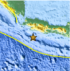
| Location | 8.223°S, 106.773°E |
| Depth | 29.7 km (18.5 miles) |
| Region | SOUTH OF JAVA, INDONESIA |
| Distances | 145 km (90 miles) S of Sukabumi, Java, Indonesia 172 km (106 miles) SSW of Bandung, Java, Indonesia 187 km (116 miles) WSW of Tasikmalaya, Java, Indonesia 226 km (140 miles) S of JAKARTA, Java, Indonesia |
| Location Uncertainty | horizontal +/- 13.8 km (8.6 miles); depth +/- 6.8 km (4.2 miles) |
| Parameters | NST= 41, Nph= 42, Dmin=136.9 km, Rmss=0.67 sec, Gp= 65°, M-type=body wave magnitude (Mb), Version=5 |
| Source |
|
| Event ID | usb0006gq5 |
- Did you feel it? Report shaking and damage at your location. You can also view a map displaying accumulated data from your report and others.

Earthquake Maps


Scientific & Technical Information
 Historic Moment Tensor Solutions
- Preliminary Earthquake Report
- U.S. Geological Survey, National Earthquake Information Center:
World Data Center for Seismology, Denver
