
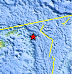
Magnitude 4.6 - FIJI REGION
2011 October 30 05:48:57 UTC
Earthquake Details
- This event has been reviewed by a seismologist.
| Magnitude | 4.6 |
|---|---|
| Date-Time |
|
| Location | 17.042°S, 178.320°W |
| Depth | 550.8 km (342.3 miles) |
| Region | FIJI REGION |
| Distances | 254 km (157 miles) ESE of Lambasa, Vanua Levu, Fiji 303 km (188 miles) S of Sigave, Ile Futuna, Wallis and Futuna 366 km (227 miles) ENE of SUVA, Viti Levu, Fiji 2300 km (1429 miles) NNE of Auckland, New Zealand |
| Location Uncertainty | horizontal +/- 24.9 km (15.5 miles); depth +/- 23.3 km (14.5 miles) |
| Parameters | NST= 16, Nph= 16, Dmin=393 km, Rmss=0.57 sec, Gp= 83°, M-type=body wave magnitude (Mb), Version=5 |
| Source |
|
| Event ID | usb0006ghm |
- Did you feel it? Report shaking and damage at your location. You can also view a map displaying accumulated data from your report and others.
Earthquake Maps


Scientific & Technical Information
 Historic Moment Tensor Solutions
- Preliminary Earthquake Report
- U.S. Geological Survey, National Earthquake Information Center:
World Data Center for Seismology, Denver
