
Magnitude 5.3 - NEAR NORTH COAST OF NEW GUINEA, P.N.G.
2011 October 30 02:10:40 UTC
Earthquake Details
- This event has been reviewed by a seismologist.
| Magnitude | 5.3 |
|---|---|
| Date-Time |
|
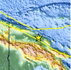
| Location | 4.348°S, 144.341°E |
| Depth | 62 km (38.5 miles) |
| Region | NEAR NORTH COAST OF NEW GUINEA, P.N.G. |
| Distances | 118 km (73 miles) SE of Wewak, New Guinea, PNG 168 km (104 miles) N of Mount Hagen, New Guinea, PNG 648 km (402 miles) NNW of PORT MORESBY, Papua New Guinea 2723 km (1691 miles) NNW of BRISBANE, Queensland, Australia |
| Location Uncertainty | horizontal +/- 14.9 km (9.3 miles); depth +/- 11.3 km (7.0 miles) |
| Parameters | NST= 80, Nph= 84, Dmin=421.9 km, Rmss=0.89 sec, Gp= 36°, M-type=body wave magnitude (Mb), Version=6 |
| Source |
|
| Event ID | usb0006gg5 |
- Did you feel it? Report shaking and damage at your location. You can also view a map displaying accumulated data from your report and others.

Earthquake Maps


Scientific & Technical Information
 Historic Moment Tensor Solutions
 Tsunami Information
The earthquake locations and magnitudes cited in NOAA tsunami statements and bulletins are preliminary and are superseded by USGS locations and magnitudes computed using more extensive data sets.
General Tsunami Information
- Preliminary Earthquake Report
- U.S. Geological Survey, National Earthquake Information Center:
World Data Center for Seismology, Denver
