
Magnitude 4.7 - NORTHERN SUMATRA, INDONESIA
2011 October 30 02:02:14 UTC
Earthquake Details
- This event has been reviewed by a seismologist.
| Magnitude | 4.7 |
|---|---|
| Date-Time |
|
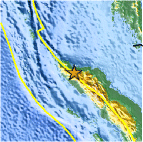
| Location | 4.892°N, 96.141°E |
| Depth | 18.6 km (11.6 miles) |
| Region | NORTHERN SUMATRA, INDONESIA |
| Distances | 116 km (72 miles) WSW of Lhokseumawe, Sumatra, Indonesia 116 km (72 miles) SE of Banda Aceh, Sumatra, Indonesia 208 km (129 miles) WNW of Langsa, Sumatra, Indonesia 1705 km (1059 miles) NW of JAKARTA, Java, Indonesia |
| Location Uncertainty | horizontal +/- 18.3 km (11.4 miles); depth +/- 8.1 km (5.0 miles) |
| Parameters | NST= 27, Nph= 27, Dmin=96.8 km, Rmss=1.44 sec, Gp= 72°, M-type=body wave magnitude (Mb), Version=5 |
| Source |
|
| Event ID | usb0006gg3 |
- Did you feel it? Report shaking and damage at your location. You can also view a map displaying accumulated data from your report and others.

Earthquake Maps


Scientific & Technical Information
 Historic Moment Tensor Solutions
- Preliminary Earthquake Report
- U.S. Geological Survey, National Earthquake Information Center:
World Data Center for Seismology, Denver
