
Magnitude 4.4 - TONGA
2011 October 30 01:44:26 UTC
Earthquake Details
- This event has been reviewed by a seismologist.
| Magnitude | 4.4 |
|---|---|
| Date-Time |
|
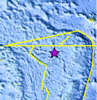
| Location | 16.303°S, 175.520°W |
| Depth | 329.4 km (204.7 miles) |
| Region | TONGA |
| Distances | 193 km (119 miles) WSW of Hihifo, Tonga 307 km (190 miles) NNW of Neiafu, Tonga 340 km (211 miles) S of MATA'UTU, Ile Uvea, Wallis and Futuna 2472 km (1536 miles) NNE of Auckland, New Zealand |
| Location Uncertainty | horizontal +/- 25.8 km (16.0 miles); depth +/- 5.7 km (3.5 miles) |
| Parameters | NST= 86, Nph= 86, Dmin=482 km, Rmss=0.61 sec, Gp=126°, M-type=body wave magnitude (Mb), Version=7 |
| Source |
|
| Event ID | usb0006gfz |
- Did you feel it? Report shaking and damage at your location. You can also view a map displaying accumulated data from your report and others.
Earthquake Maps


Scientific & Technical Information
 Historic Moment Tensor Solutions
- Preliminary Earthquake Report
- U.S. Geological Survey, National Earthquake Information Center:
World Data Center for Seismology, Denver
