
Magnitude 4.5 - SULAWESI, INDONESIA
2011 October 29 19:51:28 UTC
Earthquake Details
- This event has been reviewed by a seismologist.
| Magnitude | 4.5 |
|---|---|
| Date-Time |
|
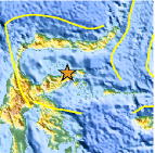
| Location | 0.824°S, 122.501°E |
| Depth | 25.1 km (15.6 miles) |
| Region | SULAWESI, INDONESIA |
| Distances | 163 km (101 miles) SSW of Gorontalo, Sulawesi, Indonesia 348 km (216 miles) N of Kendari, Sulawesi, Indonesia 1583 km (983 miles) NW of DARWIN, Northern Territory, Australia 1839 km (1142 miles) ENE of JAKARTA, Java, Indonesia |
| Location Uncertainty | horizontal +/- 30.8 km (19.1 miles); depth +/- 12.4 km (7.7 miles) |
| Parameters | NST= 19, Nph= 19, Dmin=39 km, Rmss=1.23 sec, Gp=115°, M-type=body wave magnitude (Mb), Version=4 |
| Source |
|
| Event ID | usb0006gcp |
- Did you feel it? Report shaking and damage at your location. You can also view a map displaying accumulated data from your report and others.

Earthquake Maps


Scientific & Technical Information
 Historic Moment Tensor Solutions
- Preliminary Earthquake Report
- U.S. Geological Survey, National Earthquake Information Center:
World Data Center for Seismology, Denver
