
Magnitude 4.9 - VANUATU
2011 October 29 07:34:52 UTC
Earthquake Details
- This event has been reviewed by a seismologist.
| Magnitude | 4.9 |
|---|---|
| Date-Time |
|
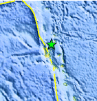
| Location | 14.538°S, 167.208°E |
| Depth | 128.4 km (79.8 miles) |
| Region | VANUATU |
| Distances | 109 km (67 miles) N of Luganville, Espiritu Santo, Vanuatu 372 km (231 miles) NNW of PORT-VILA, Efate, Vanuatu 448 km (278 miles) SSE of Lata, Santa Cruz Islands, Solomon Isl. 2055 km (1276 miles) NE of BRISBANE, Queensland, Australia |
| Location Uncertainty | horizontal +/- 23.9 km (14.9 miles); depth +/- 8.1 km (5.0 miles) |
| Parameters | NST= 39, Nph= 42, Dmin=838.2 km, Rmss=1.01 sec, Gp= 68°, M-type=body wave magnitude (Mb), Version=4 |
| Source |
|
| Event ID | usb0006g41 |
- Did you feel it? Report shaking and damage at your location. You can also view a map displaying accumulated data from your report and others.
Earthquake Maps


Scientific & Technical Information
 Historic Moment Tensor Solutions
- Preliminary Earthquake Report
- U.S. Geological Survey, National Earthquake Information Center:
World Data Center for Seismology, Denver
