
Magnitude 4.7 - SOUTHEAST OF THE LOYALTY ISLANDS
2011 October 29 06:59:41 UTC
Earthquake Details
- This event has been reviewed by a seismologist.
| Magnitude | 4.7 |
|---|---|
| Date-Time |
|
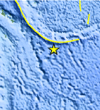
| Location | 23.674°S, 171.279°E |
| Depth | 50.1 km (31.1 miles) |
| Region | SOUTHEAST OF THE LOYALTY ISLANDS |
| Distances | 161 km (100 miles) SSW of Ile Hunter, Loyalty Isl., New Caledonia 400 km (248 miles) WSW of Ceva-i-Ra, Fiji 519 km (322 miles) ESE of NOUMEA, New Caledonia 1501 km (932 miles) NNW of Auckland, New Zealand |
| Location Uncertainty | horizontal +/- 20.8 km (12.9 miles); depth +/- 12.2 km (7.6 miles) |
| Parameters | NST= 26, Nph= 27, Dmin=527.7 km, Rmss=1.56 sec, Gp= 83°, M-type=body wave magnitude (Mb), Version=5 |
| Source |
|
| Event ID | usb0006g3p |
- Did you feel it? Report shaking and damage at your location. You can also view a map displaying accumulated data from your report and others.
Earthquake Maps


Scientific & Technical Information
 Historic Moment Tensor Solutions
- Preliminary Earthquake Report
- U.S. Geological Survey, National Earthquake Information Center:
World Data Center for Seismology, Denver
