
Magnitude 4.7 - EASTERN NEW GUINEA REG, PAPUA NEW GUINEA
2011 October 26 03:18:51 UTC
Earthquake Details
- This event has been reviewed by a seismologist.
| Magnitude | 4.7 |
|---|---|
| Date-Time |
|
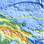
| Location | 4.440°S, 146.356°E |
| Depth | 120.3 km (74.8 miles) |
| Region | EASTERN NEW GUINEA REG, PAPUA NEW GUINEA |
| Distances | 106 km (65 miles) NE of Madang, New Guinea, PNG 211 km (131 miles) NNE of Goroka, New Guinea, PNG 563 km (349 miles) N of PORT MORESBY, Papua New Guinea 2648 km (1645 miles) NNW of BRISBANE, Queensland, Australia |
| Location Uncertainty | horizontal +/- 25.3 km (15.7 miles); depth +/- 9.6 km (6.0 miles) |
| Parameters | NST= 17, Nph= 18, Dmin=556.6 km, Rmss=0.81 sec, Gp=122°, M-type=body wave magnitude (Mb), Version=6 |
| Source |
|
| Event ID | usb0006djh |
- Did you feel it? Report shaking and damage at your location. You can also view a map displaying accumulated data from your report and others.

Earthquake Maps


Scientific & Technical Information
 Historic Moment Tensor Solutions
- Preliminary Earthquake Report
- U.S. Geological Survey, National Earthquake Information Center:
World Data Center for Seismology, Denver
