
Magnitude 4.8 - SOUTH OF THE FIJI ISLANDS
2011 October 26 00:13:22 UTC
Earthquake Details
- This event has been reviewed by a seismologist.
| Magnitude | 4.8 |
|---|---|
| Date-Time |
|
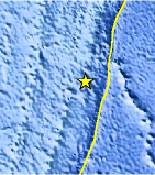
| Location | 26.812°S, 176.612°W |
| Depth | 36 km (22.4 miles) |
| Region | SOUTH OF THE FIJI ISLANDS |
| Distances | 300 km (186 miles) NNE of Raoul Island, Kermadec Islands 558 km (346 miles) NNE of L'Esperance Rock, Kermadec Islands 644 km (400 miles) SSW of NUKU`ALOFA, Tonga 1381 km (858 miles) NE of Auckland, New Zealand |
| Location Uncertainty | horizontal +/- 26.3 km (16.3 miles); depth +/- 8.5 km (5.3 miles) |
| Parameters | NST= 32, Nph= 32, Dmin=299.4 km, Rmss=1.41 sec, Gp=115°, M-type=body wave magnitude (Mb), Version=3 |
| Source |
|
| Event ID | usb0006di1 |
- Did you feel it? Report shaking and damage at your location. You can also view a map displaying accumulated data from your report and others.
Earthquake Maps


Scientific & Technical Information
 Historic Moment Tensor Solutions
- Preliminary Earthquake Report
- U.S. Geological Survey, National Earthquake Information Center:
World Data Center for Seismology, Denver
