
Magnitude 4.5 - NEAR THE NORTH COAST OF PAPUA, INDONESIA
2011 October 25 08:50:30 UTC
Earthquake Details
- This event has been reviewed by a seismologist.
| Magnitude | 4.5 |
|---|---|
| Date-Time |
|
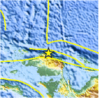
| Location | 0.357°S, 132.905°E |
| Depth | 41.1 km (25.5 miles) |
| Region | NEAR THE NORTH COAST OF PAPUA, INDONESIA |
| Distances | 143 km (88 miles) WNW of Manokwari, Papua, Indonesia 192 km (119 miles) ENE of Sorong, Papua, Indonesia 869 km (539 miles) SSW of KOROR, Palau 1358 km (843 miles) N of DARWIN, Northern Territory, Australia |
| Location Uncertainty | horizontal +/- 23.9 km (14.9 miles); depth +/- 7.4 km (4.6 miles) |
| Parameters | NST= 21, Nph= 22, Dmin=292.8 km, Rmss=0.8 sec, Gp= 68°, M-type=body wave magnitude (Mb), Version=4 |
| Source |
|
| Event ID | usb0006cqy |
- Did you feel it? Report shaking and damage at your location. You can also view a map displaying accumulated data from your report and others.

Earthquake Maps


Scientific & Technical Information
 Historic Moment Tensor Solutions
- Preliminary Earthquake Report
- U.S. Geological Survey, National Earthquake Information Center:
World Data Center for Seismology, Denver
