
Magnitude 4.8 - NEAR NORTH COAST OF NEW GUINEA, P.N.G.
2011 October 23 08:26:55 UTC
Earthquake Details
- This event has been reviewed by a seismologist.
| Magnitude | 4.8 |
|---|---|
| Date-Time |
|
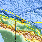
| Location | 3.026°S, 142.356°E |
| Depth | 24.7 km (15.3 miles) |
| Region | NEAR NORTH COAST OF NEW GUINEA, P.N.G. |
| Distances | 127 km (78 miles) ESE of Vanimo, New Guinea, PNG 152 km (94 miles) WNW of Wewak, New Guinea, PNG 890 km (553 miles) NW of PORT MORESBY, Papua New Guinea 2936 km (1824 miles) NNW of BRISBANE, Queensland, Australia |
| Location Uncertainty | horizontal +/- 17.4 km (10.8 miles); depth +/- 6.7 km (4.2 miles) |
| Parameters | NST= 44, Nph= 45, Dmin=567.7 km, Rmss=0.9 sec, Gp= 54°, M-type=body wave magnitude (Mb), Version=7 |
| Source |
|
| Event ID | usb0006bpq |
- Did you feel it? Report shaking and damage at your location. You can also view a map displaying accumulated data from your report and others.

Earthquake Maps


Scientific & Technical Information
 Historic Moment Tensor Solutions
- Preliminary Earthquake Report
- U.S. Geological Survey, National Earthquake Information Center:
World Data Center for Seismology, Denver
