
Magnitude 4.7 - SOUTHWEST OF SUMATRA, INDONESIA
2011 October 23 05:17:43 UTC
Earthquake Details
- This event has been reviewed by a seismologist.
| Magnitude | 4.7 |
|---|---|
| Date-Time |
|
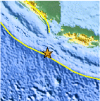
| Location | 8.220°S, 104.768°E |
| Depth | 27.9 km (17.3 miles) |
| Region | SOUTHWEST OF SUMATRA, INDONESIA |
| Distances | 270 km (167 miles) NNW of Christmas Island 278 km (172 miles) WSW of Sukabumi, Java, Indonesia 282 km (175 miles) SSW of Cilegon, Java, Indonesia 320 km (198 miles) SW of JAKARTA, Java, Indonesia |
| Location Uncertainty | horizontal +/- 22.1 km (13.7 miles); depth +/- 9.4 km (5.8 miles) |
| Parameters | NST= 31, Nph= 34, Dmin=268.3 km, Rmss=0.9 sec, Gp=144°, M-type=body wave magnitude (Mb), Version=6 |
| Source |
|
| Event ID | usb0006bnb |
- Did you feel it? Report shaking and damage at your location. You can also view a map displaying accumulated data from your report and others.
Earthquake Maps


Scientific & Technical Information
 Historic Moment Tensor Solutions
- Preliminary Earthquake Report
- U.S. Geological Survey, National Earthquake Information Center:
World Data Center for Seismology, Denver
