
Magnitude 4.9 - NEW BRITAIN REGION, PAPUA NEW GUINEA
2011 October 22 19:49:08 UTC
Earthquake Details
- This event has been reviewed by a seismologist.
| Magnitude | 4.9 |
|---|---|
| Date-Time |
|
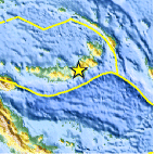
| Location | 5.713°S, 151.087°E |
| Depth | 48.3 km (30.0 miles) |
| Region | NEW BRITAIN REGION, PAPUA NEW GUINEA |
| Distances | 105 km (65 miles) E of Kimbe, New Britain, PNG 179 km (111 miles) ENE of Kandrian, New Britain, PNG 598 km (371 miles) NE of PORT MORESBY, Papua New Guinea 2420 km (1503 miles) N of BRISBANE, Queensland, Australia |
| Location Uncertainty | horizontal +/- 24.5 km (15.2 miles); depth +/- 2.6 km (1.6 miles) |
| Parameters | NST= 34, Nph= 34, Dmin=205.9 km, Rmss=0.88 sec, Gp= 79°, M-type=body wave magnitude (Mb), Version=4 |
| Source |
|
| Event ID | usb0006bj2 |
- Did you feel it? Report shaking and damage at your location. You can also view a map displaying accumulated data from your report and others.

Earthquake Maps


Scientific & Technical Information
 Historic Moment Tensor Solutions
- Preliminary Earthquake Report
- U.S. Geological Survey, National Earthquake Information Center:
World Data Center for Seismology, Denver
