
Magnitude 4.6 - MINAHASA, SULAWESI, INDONESIA
2011 October 22 07:36:03 UTC
Earthquake Details
- This event has been reviewed by a seismologist.
| Magnitude | 4.6 |
|---|---|
| Date-Time |
|
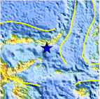
| Location | 0.095°N, 123.729°E |
| Depth | 187 km (116.2 miles) |
| Region | MINAHASA, SULAWESI, INDONESIA |
| Distances | 89 km (55 miles) SE of Gorontalo, Sulawesi, Indonesia 198 km (123 miles) SW of Manado, Sulawesi, Indonesia 979 km (608 miles) NNW of DILI, Timor-Leste 1632 km (1014 miles) S of MANILA, Philippines |
| Location Uncertainty | horizontal +/- 24.8 km (15.4 miles); depth +/- 9.4 km (5.8 miles) |
| Parameters | NST= 64, Nph= 68, Dmin=716.9 km, Rmss=1.22 sec, Gp= 86°, M-type=body wave magnitude (Mb), Version=5 |
| Source |
|
| Event ID | usb0006ber |
- Did you feel it? Report shaking and damage at your location. You can also view a map displaying accumulated data from your report and others.

Earthquake Maps


Scientific & Technical Information
 Historic Moment Tensor Solutions
- Preliminary Earthquake Report
- U.S. Geological Survey, National Earthquake Information Center:
World Data Center for Seismology, Denver
