
Magnitude 4.7 - TONGA
2011 October 22 05:24:37 UTC
Earthquake Details
- This event has been reviewed by a seismologist.
| Magnitude | 4.7 |
|---|---|
| Date-Time |
|
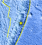
| Location | 20.159°S, 174.038°W |
| Depth | 46.9 km (29.1 miles) |
| Region | TONGA |
| Distances | 161 km (100 miles) NE of NUKU`ALOFA, Tonga 167 km (103 miles) S of Neiafu, Tonga 455 km (282 miles) WSW of Niue Island 2148 km (1334 miles) NNE of Auckland, New Zealand |
| Location Uncertainty | horizontal +/- 21.2 km (13.2 miles); depth +/- 2.9 km (1.8 miles) |
| Parameters | NST= 78, Nph= 78, Dmin=732.5 km, Rmss=0.69 sec, Gp=119°, M-type=body wave magnitude (Mb), Version=5 |
| Source |
|
| Event ID | usb0006bec |
- Did you feel it? Report shaking and damage at your location. You can also view a map displaying accumulated data from your report and others.
Earthquake Maps


Scientific & Technical Information
 Historic Moment Tensor Solutions
- Preliminary Earthquake Report
- U.S. Geological Survey, National Earthquake Information Center:
World Data Center for Seismology, Denver
