
Magnitude 4.6 - SULAWESI, INDONESIA
2011 October 21 05:50:22 UTC
Earthquake Details
- This event has been reviewed by a seismologist.
| Magnitude | 4.6 |
|---|---|
| Date-Time |
|
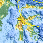
| Location | 1.530°S, 119.526°E |
| Depth | 43.9 km (27.3 miles) |
| Region | SULAWESI, INDONESIA |
| Distances | 177 km (109 miles) NNW of Palopo, Sulawesi, Indonesia 271 km (168 miles) S of Palu, Sulawesi, Indonesia 288 km (178 miles) ESE of Samarinda, Kalimantan, Indonesia 1501 km (932 miles) ENE of JAKARTA, Java, Indonesia |
| Location Uncertainty | horizontal +/- 23.2 km (14.4 miles); depth +/- 10.4 km (6.5 miles) |
| Parameters | NST= 37, Nph= 38, Dmin=750.3 km, Rmss=0.5 sec, Gp= 97°, M-type=body wave magnitude (Mb), Version=5 |
| Source |
|
| Event ID | usb0006azl |
- Did you feel it? Report shaking and damage at your location. You can also view a map displaying accumulated data from your report and others.

Earthquake Maps


Scientific & Technical Information
 Historic Moment Tensor Solutions
- Preliminary Earthquake Report
- U.S. Geological Survey, National Earthquake Information Center:
World Data Center for Seismology, Denver
