
Magnitude 4.8 - PHILIPPINE ISLANDS REGION
2011 October 19 11:29:35 UTC
Earthquake Details
- This event has been reviewed by a seismologist.
| Magnitude | 4.8 |
|---|---|
| Date-Time |
|
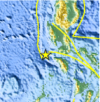
| Location | 13.725°N, 119.651°E |
| Depth | 59.2 km (36.8 miles) |
| Region | PHILIPPINE ISLANDS REGION |
| Distances | 140 km (86 miles) SSW of Olongapo, Luzon, Philippines 152 km (94 miles) W of Batangas, Luzon, Philippines 169 km (105 miles) WNW of Calapan, Mindoro, Philippines 173 km (107 miles) SW of MANILA, Philippines |
| Location Uncertainty | horizontal +/- 25.3 km (15.7 miles); depth +/- 14.9 km (9.3 miles) |
| Parameters | NST= 26, Nph= 27, Dmin=954 km, Rmss=1.23 sec, Gp=137°, M-type=body wave magnitude (Mb), Version=7 |
| Source |
|
| Event ID | usb0006a3l |
- Did you feel it? Report shaking and damage at your location. You can also view a map displaying accumulated data from your report and others.
Earthquake Maps


Scientific & Technical Information
 Historic Moment Tensor Solutions
- Preliminary Earthquake Report
- U.S. Geological Survey, National Earthquake Information Center:
World Data Center for Seismology, Denver
