
Magnitude 4.8 - NEAR THE SOUTH COAST OF PAPUA, INDONESIA
2011 October 19 04:54:24 UTC
Earthquake Details
- This event has been reviewed by a seismologist.
| Magnitude | 4.8 |
|---|---|
| Date-Time |
|
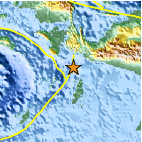
| Location | 4.804°S, 134.150°E |
| Depth | 9.8 km (6.1 miles) |
| Region | NEAR THE SOUTH COAST OF PAPUA, INDONESIA |
| Distances | 107 km (66 miles) N of Dobo, Kepulauan Aru, Indonesia 265 km (164 miles) WSW of Enarotali, Papua, Indonesia 434 km (269 miles) S of Manokwari, Papua, Indonesia 923 km (573 miles) NNE of DARWIN, Northern Territory, Australia |
| Location Uncertainty | horizontal +/- 21.1 km (13.1 miles); depth +/- 2.9 km (1.8 miles) |
| Parameters | NST= 33, Nph= 40, Dmin=297.2 km, Rmss=1.38 sec, Gp= 86°, M-type=body wave magnitude (Mb), Version=6 |
| Source |
|
| Event ID | usb0006a0h |
- Did you feel it? Report shaking and damage at your location. You can also view a map displaying accumulated data from your report and others.

Earthquake Maps


Scientific & Technical Information
 Historic Moment Tensor Solutions
- Preliminary Earthquake Report
- U.S. Geological Survey, National Earthquake Information Center:
World Data Center for Seismology, Denver
