
Magnitude 4.9 - TIMOR REGION
2011 October 19 00:50:44 UTC
Earthquake Details
- This event has been reviewed by a seismologist.
| Magnitude | 4.9 |
|---|---|
| Date-Time |
|
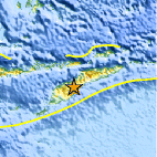
| Location | 9.487°S, 124.759°E |
| Depth | 29.2 km (18.1 miles) |
| Region | TIMOR REGION |
| Distances | 129 km (80 miles) SW of DILI, Timor-Leste 157 km (97 miles) ENE of Kupang, Timor, Indonesia 735 km (456 miles) WNW of DARWIN, Northern Territory, Australia 2018 km (1253 miles) ESE of JAKARTA, Java, Indonesia |
| Location Uncertainty | horizontal +/- 7.3 km (4.5 miles); depth +/- 13.3 km (8.3 miles) |
| Parameters | NST= 49, Nph= 49, Dmin=61.6 km, Rmss=1.11 sec, Gp= 40°, M-type=body wave magnitude (Mb), Version=5 |
| Source |
|
| Event ID | usb00069y1 |
- Did you feel it? Report shaking and damage at your location. You can also view a map displaying accumulated data from your report and others.

Earthquake Maps


Scientific & Technical Information
 Historic Moment Tensor Solutions
- Preliminary Earthquake Report
- U.S. Geological Survey, National Earthquake Information Center:
World Data Center for Seismology, Denver
