
Magnitude 4.8 - KEPULAUAN MENTAWAI REGION, INDONESIA
2011 October 18 18:19:22 UTC
Earthquake Details
- This event has been reviewed by a seismologist.
| Magnitude | 4.8 |
|---|---|
| Date-Time |
|
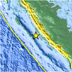
| Location | 2.975°S, 100.949°E |
| Depth | 40.8 km (25.4 miles) |
| Region | KEPULAUAN MENTAWAI REGION, INDONESIA |
| Distances | 172 km (106 miles) WNW of Bengkulu, Sumatra, Indonesia 215 km (133 miles) W of Lubuklinggau, Sumatra, Indonesia 572 km (355 miles) SW of SINGAPORE 742 km (461 miles) WNW of JAKARTA, Java, Indonesia |
| Location Uncertainty | horizontal +/- 22.9 km (14.2 miles); depth +/- 10.5 km (6.5 miles) |
| Parameters | NST= 43, Nph= 48, Dmin=270.3 km, Rmss=1.25 sec, Gp=119°, M-type=body wave magnitude (Mb), Version=6 |
| Source |
|
| Event ID | usb00069l8 |
- Did you feel it? Report shaking and damage at your location. You can also view a map displaying accumulated data from your report and others.

Earthquake Maps


Scientific & Technical Information
 Historic Moment Tensor Solutions
- Preliminary Earthquake Report
- U.S. Geological Survey, National Earthquake Information Center:
World Data Center for Seismology, Denver
