
Magnitude 4.6 - BANDA SEA
2011 January 28 21:33:41 UTC
Earthquake Details
- This event has been reviewed by a seismologist.
| Magnitude | 4.6 |
|---|---|
| Date-Time |
|
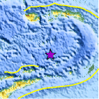
| Location | 6.467°S, 128.079°E |
| Depth | 335.3 km (208.4 miles) |
| Region | BANDA SEA |
| Distances | 305 km (190 miles) S of Ambon, Moluccas, Indonesia 360 km (225 miles) NE of DILI, Timor-Leste 730 km (450 miles) NNW of DARWIN, Northern Territory, Australia 2355 km (1460 miles) E of JAKARTA, Java, Indonesia |
| Location Uncertainty | horizontal +/- 14.3 km (8.9 miles); depth +/- 10.8 km (6.7 miles) |
| Parameters | NST= 49, Nph= 51, Dmin=393 km, Rmss=0.8 sec, Gp= 36°, M-type=body wave magnitude (Mb), Version=4 |
| Source |
|
| Event ID | usb00015s4 |
- Did you feel it? Report shaking and damage at your location. You can also view a map displaying accumulated data from your report and others.

Earthquake Maps


Scientific & Technical Information
 Historic Moment Tensor Solutions
- Preliminary Earthquake Report
- U.S. Geological Survey, National Earthquake Information Center:
World Data Center for Seismology, Denver
