
Magnitude 4.9 - FIJI REGION
2011 January 28 12:41:01 UTC
Earthquake Details
- This event has been reviewed by a seismologist.
| Magnitude | 4.9 |
|---|---|
| Date-Time |
|
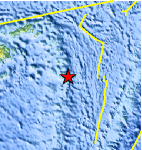
| Location | 19.152°S, 178.160°W |
| Depth | 602.8 km (374.6 miles) |
| Region | FIJI REGION |
| Distances | 175 km (110 miles) NNE of Ndoi Island, Fiji 380 km (235 miles) ESE of SUVA, Viti Levu, Fiji 380 km (235 miles) NW of NUKU`ALOFA, Tonga 2085 km (1290 miles) NNE of Auckland, New Zealand |
| Location Uncertainty | horizontal +/- 20.1 km (12.5 miles); depth +/- 3.9 km (2.4 miles) |
| Parameters | NST=272, Nph=277, Dmin=895 km, Rmss=0.86 sec, Gp=126°, M-type=body wave magnitude (Mb), Version=7 |
| Source |
|
| Event ID | usb00015iq |
- Did you feel it? Report shaking and damage at your location. You can also view a map displaying accumulated data from your report and others.
Earthquake Maps


Scientific & Technical Information
 Historic Moment Tensor Solutions
- Preliminary Earthquake Report
- U.S. Geological Survey, National Earthquake Information Center:
World Data Center for Seismology, Denver
