
Magnitude 6.0 - TONGA
2010 November 03 23:34:44 UTC
Earthquake Details
- This event has been reviewed by a seismologist.
| Magnitude | 6.0 |
|---|---|
| Date-Time |
|
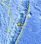
| Location | 20.440°S, 174.290°W |
| Depth | 33.2 km (20.6 miles) |
| Region | TONGA |
| Distances | 120 km (75 miles) NE of NUKU`ALOFA, Tonga 200 km (125 miles) S of Neiafu, Tonga 460 km (285 miles) E of Ndoi Island, Fiji 2100 km (1310 miles) NNE of Auckland, New Zealand |
| Location Uncertainty | horizontal +/- 20.3 km (12.6 miles); depth +/- 1.1 km (0.7 miles) |
| Parameters | NST=309, Nph=311, Dmin=>999 km, Rmss=0.7 sec, Gp= 40°, M-type=teleseismic moment magnitude (Mw), Version=9 |
| Source |
|
| Event ID | usb0000abs |
- Did you feel it? Report shaking and damage at your location. You can also view a map displaying accumulated data from your report and others.
Earthquake Maps


Scientific & Technical Information

 Tsunami Information
The earthquake locations and magnitudes cited in NOAA tsunami statements and bulletins are preliminary and are superseded by USGS locations and magnitudes computed using more extensive data sets.
NOAA Tsunami Bulletins for this Earthquake
No Bulletins have been issued at this time.
General Tsunami Information
- Preliminary Earthquake Report
- U.S. Geological Survey, National Earthquake Information Center:
World Data Center for Seismology, Denver
