
Magnitude 5.1 - SIBUYAN SEA, PHILIPPINES
2010 November 03 22:24:49 UTC
Earthquake Details
- This event has been reviewed by a seismologist.
| Magnitude | 5.1 |
|---|---|
| Date-Time |
|
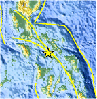
| Location | 12.707°N, 122.965°E |
| Depth | 37.7 km (23.4 miles) set by location program |
| Region | SIBUYAN SEA, PHILIPPINES |
| Distances | 80 km (50 miles) WNW of Masbate, Masbate, Philippines 95 km (60 miles) WSW of Legaspi, Luzon, Philippines 105 km (65 miles) SSW of Naga, Luzon, Philippines 300 km (185 miles) SE of MANILA, Philippines |
| Location Uncertainty | horizontal +/- 18.3 km (11.4 miles); depth fixed by location program |
| Parameters | NST= 68, Nph= 70, Dmin=600 km, Rmss=1.22 sec, Gp= 90°, M-type=body wave magnitude (Mb), Version=9 |
| Source |
|
| Event ID | usb0000ab5 |
- Did you feel it? Report shaking and damage at your location. You can also view a map displaying accumulated data from your report and others.

Earthquake Maps


Scientific & Technical Information
 Historic Moment Tensor Solutions
- Preliminary Earthquake Report
- U.S. Geological Survey, National Earthquake Information Center:
World Data Center for Seismology, Denver
