
Magnitude 6.0 - NEAR THE SOUTH COAST OF PAPUA, INDONESIA
2010 November 03 11:18:16 UTC
Earthquake Details
- This event has been reviewed by a seismologist.
| Magnitude | 6.0 |
|---|---|
| Date-Time |
|
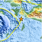
| Location | 4.614°S, 134.040°E |
| Depth | 14.8 km (9.2 miles) set by location program |
| Region | NEAR THE SOUTH COAST OF PAPUA, INDONESIA |
| Distances | 130 km (80 miles) N of Dobo, Kepulauan Aru, Indonesia 270 km (170 miles) WSW of Enarotali, Papua, Indonesia 930 km (580 miles) NNE of DARWIN, Northern Territory, Australia 3015 km (1870 miles) E of JAKARTA, Java, Indonesia |
| Location Uncertainty | horizontal +/- 14 km (8.7 miles); depth fixed by location program |
| Parameters | NST=154, Nph=154, Dmin=273.8 km, Rmss=1.29 sec, Gp= 22°, M-type=centroid moment magnitude (Mw), Version=9 |
| Source |
|
| Event ID | usb00009wf |
- Did you feel it? Report shaking and damage at your location. You can also view a map displaying accumulated data from your report and others.

Earthquake Maps


- Preliminary Earthquake Report
- U.S. Geological Survey, National Earthquake Information Center:
World Data Center for Seismology, Denver
