
Magnitude 4.5 - CERAM SEA, INDONESIA
2010 November 03 09:09:54 UTC
Earthquake Details
- This event has been reviewed by a seismologist.
| Magnitude | 4.5 |
|---|---|
| Date-Time |
|
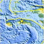
| Location | 2.878°S, 128.931°E |
| Depth | 35.2 km (21.9 miles) |
| Region | CERAM SEA, INDONESIA |
| Distances | 125 km (75 miles) NE of Ambon, Moluccas, Indonesia 340 km (210 miles) SW of Sorong, Papua, Indonesia 1080 km (670 miles) NNW of DARWIN, Northern Territory, Australia 2475 km (1540 miles) E of JAKARTA, Java, Indonesia |
| Location Uncertainty | horizontal +/- 26.5 km (16.5 miles); depth +/- 0.5 km (0.3 miles) |
| Parameters | NST= 8, Nph= 8, Dmin=368.5 km, Rmss=0.74 sec, Gp=166°, M-type=body wave magnitude (Mb), Version=3 |
| Source |
|
| Event ID | usb00009vc |
- Did you feel it? Report shaking and damage at your location. You can also view a map displaying accumulated data from your report and others.

Earthquake Maps


Scientific & Technical Information
 Historic Moment Tensor Solutions
- Preliminary Earthquake Report
- U.S. Geological Survey, National Earthquake Information Center:
World Data Center for Seismology, Denver
