
Magnitude 4.9 - KEPULAUAN BARAT DAYA, INDONESIA
2010 November 03 05:11:34 UTC
Earthquake Details
- This event has been reviewed by a seismologist.
| Magnitude | 4.9 |
|---|---|
| Date-Time |
|
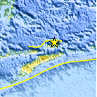
| Location | 7.559°S, 126.494°E |
| Depth | 38.9 km (24.2 miles) |
| Region | KEPULAUAN BARAT DAYA, INDONESIA |
| Distances | 150 km (95 miles) NE of DILI, Timor-Leste 430 km (265 miles) NE of Kupang, Timor, Indonesia 465 km (290 miles) SSW of Ambon, Moluccas, Indonesia 720 km (450 miles) NW of DARWIN, Northern Territory, Australia |
| Location Uncertainty | horizontal +/- 18.1 km (11.2 miles); depth +/- 1.3 km (0.8 miles) |
| Parameters | NST= 45, Nph= 48, Dmin=345.1 km, Rmss=1.28 sec, Gp= 68°, M-type=body wave magnitude (Mb), Version=5 |
| Source |
|
| Event ID | usb00009ud |
- Did you feel it? Report shaking and damage at your location. You can also view a map displaying accumulated data from your report and others.

Earthquake Maps


Scientific & Technical Information
 Historic Moment Tensor Solutions
- Preliminary Earthquake Report
- U.S. Geological Survey, National Earthquake Information Center:
World Data Center for Seismology, Denver
