
Magnitude 4.7 - KEPULAUAN KAI, INDONESIA
2010 October 26 04:54:48 UTC
Earthquake Details
- This event has been reviewed by a seismologist.
| Magnitude | 4.7 |
|---|---|
| Date-Time |
|
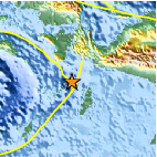
| Location | 5.177°S, 133.672°E |
| Depth | 10.2 km (6.3 miles) |
| Region | KEPULAUAN KAI, INDONESIA |
| Distances | 90 km (55 miles) NW of Dobo, Kepulauan Aru, Indonesia 330 km (205 miles) WSW of Enarotali, Papua, Indonesia 870 km (540 miles) NNE of DARWIN, Northern Territory, Australia 2970 km (1850 miles) E of JAKARTA, Java, Indonesia |
| Location Uncertainty | horizontal +/- 19.9 km (12.4 miles); depth +/- 0.7 km (0.4 miles) |
| Parameters | NST= 24, Nph= 27, Dmin=295 km, Rmss=1.32 sec, Gp=137°, M-type=body wave magnitude (Mb), Version=7 |
| Source |
|
| Event ID | usb00006ut |
- Did you feel it? Report shaking and damage at your location. You can also view a map displaying accumulated data from your report and others.

Earthquake Maps


Scientific & Technical Information
 Historic Moment Tensor Solutions
- Preliminary Earthquake Report
- U.S. Geological Survey, National Earthquake Information Center:
World Data Center for Seismology, Denver
