
Magnitude 4.8 - BANDA SEA
2010 October 31 19:23:44 UTC
Earthquake Details
- This event has been reviewed by a seismologist.
| Magnitude | 4.8 |
|---|---|
| Date-Time |
|
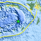
| Location | 6.188°S, 130.535°E |
| Depth | 150 km (93.2 miles) |
| Region | BANDA SEA |
| Distances | 215 km (130 miles) NNW of Saumlaki, Kepulauan Tanimbar, Indonesia 380 km (235 miles) SE of Ambon, Moluccas, Indonesia 695 km (430 miles) N of DARWIN, Northern Territory, Australia 2625 km (1630 miles) E of JAKARTA, Java, Indonesia |
| Location Uncertainty | horizontal +/- 21.1 km (13.1 miles); depth +/- 9.4 km (5.8 miles) |
| Parameters | NST= 22, Nph= 23, Dmin=216 km, Rmss=1.04 sec, Gp= 76°, M-type=body wave magnitude (Mb), Version=4 |
| Source |
|
| Event ID | usa00046ln |
- Did you feel it? Report shaking and damage at your location. You can also view a map displaying accumulated data from your report and others.

Earthquake Maps


Scientific & Technical Information
 Historic Moment Tensor Solutions
- Preliminary Earthquake Report
- U.S. Geological Survey, National Earthquake Information Center:
World Data Center for Seismology, Denver
