
Magnitude 5.1 - NEW BRITAIN REGION, PAPUA NEW GUINEA
2010 October 31 18:49:14 UTC
Earthquake Details
- This event has been reviewed by a seismologist.
| Magnitude | 5.1 |
|---|---|
| Date-Time |
|
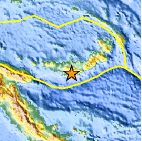
| Location | 6.223°S, 150.036°E |
| Depth | 22.9 km (14.2 miles) |
| Region | NEW BRITAIN REGION, PAPUA NEW GUINEA |
| Distances | 55 km (35 miles) E of Kandrian, New Britain, PNG 75 km (45 miles) S of Kimbe, New Britain, PNG 475 km (295 miles) NE of PORT MORESBY, Papua New Guinea 2370 km (1470 miles) N of BRISBANE, Queensland, Australia |
| Location Uncertainty | horizontal +/- 24.3 km (15.1 miles); depth +/- 3.4 km (2.1 miles) |
| Parameters | NST= 16, Nph= 16, Dmin=326.2 km, Rmss=1.19 sec, Gp=108°, M-type=body wave magnitude (Mb), Version=5 |
| Source |
|
| Event ID | usa00046lg |
- Did you feel it? Report shaking and damage at your location. You can also view a map displaying accumulated data from your report and others.

Earthquake Maps


Scientific & Technical Information
 Historic Moment Tensor Solutions
 Tsunami Information
The earthquake locations and magnitudes cited in NOAA tsunami statements and bulletins are preliminary and are superseded by USGS locations and magnitudes computed using more extensive data sets.
NOAA Tsunami Bulletins for this Earthquake
No Bulletins have been issued at this time.
General Tsunami Information
- Preliminary Earthquake Report
- U.S. Geological Survey, National Earthquake Information Center:
World Data Center for Seismology, Denver
