
Magnitude 4.9 - FLORES SEA
2010 October 30 17:45:46 UTC
Earthquake Details
- This event has been reviewed by a seismologist.
| Magnitude | 4.9 |
|---|---|
| Date-Time |
|
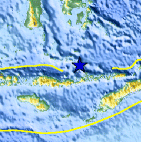
| Location | 7.724°S, 122.487°E |
| Depth | 257.1 km (159.8 miles) |
| Region | FLORES SEA |
| Distances | 155 km (95 miles) NE of Ende, Flores, Indonesia 250 km (155 miles) S of Baubau, Sulawesi, Indonesia 1050 km (650 miles) WNW of DARWIN, Northern Territory, Australia 1740 km (1080 miles) E of JAKARTA, Java, Indonesia |
| Location Uncertainty | horizontal +/- 14 km (8.7 miles); depth +/- 0.2 km (0.1 miles) |
| Parameters | NST= 62, Nph= 71, Dmin=104.6 km, Rmss=1.29 sec, Gp= 58°, M-type=body wave magnitude (Mb), Version=7 |
| Source |
|
| Event ID | usa00046gc |
- Did you feel it? Report shaking and damage at your location. You can also view a map displaying accumulated data from your report and others.

Earthquake Maps


Scientific & Technical Information
 Historic Moment Tensor Solutions
- Preliminary Earthquake Report
- U.S. Geological Survey, National Earthquake Information Center:
World Data Center for Seismology, Denver
