
Magnitude 4.8 - NEW BRITAIN REGION, PAPUA NEW GUINEA
2010 October 30 07:49:58 UTC
Earthquake Details
- This event has been reviewed by a seismologist.
| Magnitude | 4.8 |
|---|---|
| Date-Time |
|
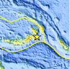
| Location | 5.298°S, 152.239°E |
| Depth | 63.3 km (39.3 miles) |
| Region | NEW BRITAIN REGION, PAPUA NEW GUINEA |
| Distances | 120 km (75 miles) S of Rabaul, New Britain, PNG 125 km (80 miles) SW of Taron, New Ireland, PNG 720 km (450 miles) NE of PORT MORESBY, Papua New Guinea 2460 km (1530 miles) N of BRISBANE, Queensland, Australia |
| Location Uncertainty | horizontal +/- 31.7 km (19.7 miles); depth +/- 5 km (3.1 miles) |
| Parameters | NST= 29, Nph= 29, Dmin=122.5 km, Rmss=0.76 sec, Gp=155°, M-type=body wave magnitude (Mb), Version=4 |
| Source |
|
| Event ID | usa00046d9 |
- Did you feel it? Report shaking and damage at your location. You can also view a map displaying accumulated data from your report and others.

Earthquake Maps


Scientific & Technical Information
 Historic Moment Tensor Solutions
- Preliminary Earthquake Report
- U.S. Geological Survey, National Earthquake Information Center:
World Data Center for Seismology, Denver
