
Magnitude 4.7 - SOUTHWEST OF SUMATRA, INDONESIA
2010 October 30 00:55:35 UTC
Earthquake Details
- This event has been reviewed by a seismologist.
| Magnitude | 4.7 |
|---|---|
| Date-Time |
|
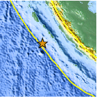
| Location | 3.589°S, 99.513°E |
| Depth | 22.8 km (14.2 miles) |
| Region | SOUTHWEST OF SUMATRA, INDONESIA |
| Distances | 305 km (190 miles) SSW of Padang, Sumatra, Indonesia 305 km (190 miles) W of Bengkulu, Sumatra, Indonesia 375 km (230 miles) W of Lubuklinggau, Sumatra, Indonesia 855 km (530 miles) WNW of JAKARTA, Java, Indonesia |
| Location Uncertainty | horizontal +/- 22.9 km (14.2 miles); depth +/- 2.8 km (1.7 miles) |
| Parameters | NST= 35, Nph= 36, Dmin=391.8 km, Rmss=1.1 sec, Gp=119°, M-type=body wave magnitude (Mb), Version=6 |
| Source |
|
| Event ID | usa00046c7 |
- Did you feel it? Report shaking and damage at your location. You can also view a map displaying accumulated data from your report and others.
Earthquake Maps


Scientific & Technical Information
 Historic Moment Tensor Solutions
- Preliminary Earthquake Report
- U.S. Geological Survey, National Earthquake Information Center:
World Data Center for Seismology, Denver
