
Magnitude 4.9 - FIJI REGION
2010 October 26 05:16:54 UTC
Earthquake Details
- This event has been reviewed by a seismologist.
| Magnitude | 4.9 |
|---|---|
| Date-Time |
|
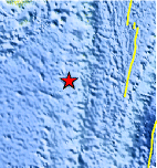
| Location | 21.916°S, 179.484°W |
| Depth | 579.5 km (360.1 miles) |
| Region | FIJI REGION |
| Distances | 160 km (100 miles) SSW of Ndoi Island, Fiji 450 km (280 miles) WSW of NUKU`ALOFA, Tonga 470 km (295 miles) SSE of SUVA, Viti Levu, Fiji 1740 km (1080 miles) NNE of Auckland, New Zealand |
| Location Uncertainty | horizontal +/- 15.8 km (9.8 miles); depth +/- 10.2 km (6.3 miles) |
| Parameters | NST= 37, Nph= 38, Dmin=528.8 km, Rmss=0.74 sec, Gp=119°, M-type=body wave magnitude (Mb), Version=4 |
| Source |
|
| Event ID | usa00044jm |
- Did you feel it? Report shaking and damage at your location. You can also view a map displaying accumulated data from your report and others.
Earthquake Maps


Scientific & Technical Information
 Historic Moment Tensor Solutions
- Preliminary Earthquake Report
- U.S. Geological Survey, National Earthquake Information Center:
World Data Center for Seismology, Denver
