
Magnitude 6.2 - KEPULAUAN BARAT DAYA, INDONESIA
2010 February 15 21:51:48 UTC
Earthquake Details
| Magnitude | 6.2 |
|---|---|
| Date-Time |
|
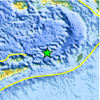
| Location | 7.256°S, 128.794°E |
| Depth | 128 km (79.5 miles) |
| Region | KEPULAUAN BARAT DAYA, INDONESIA |
| Distances | 300 km (185 miles) WNW of Saumlaki, Tanimbar Islands, Indonesia 385 km (240 miles) ENE of DILI, East Timor 625 km (390 miles) NNW of DARWIN, Northern Territory, Australia 2430 km (1510 miles) E of JAKARTA, Java, Indonesia |
| Location Uncertainty | horizontal +/- 7.6 km (4.7 miles); depth +/- 11.4 km (7.1 miles) |
| Parameters | NST= 45, Nph= 47, Dmin=288.3 km, Rmss=0.81 sec, Gp= 58°, M-type=teleseismic moment magnitude (Mw), Version=6 |
| Source |
|
| Event ID | us2010stbl |
- This event has been reviewed by a seismologist.
- Did you feel it? Report shaking and damage at your location. You can also view a map displaying accumulated data from your report and others.

Earthquake Maps


Scientific & Technical Information

 Historic Moment Tensor Solutions
 Tsunami Information
The earthquake locations and magnitudes cited in NOAA tsunami bulletins are very preliminary and may be superseded by USGS locations and magnitudes computed using more extensive data sets.
Tsunami Bulletins for this Earthquake
No Bulletins have been issued at this time.
General Tsunami Information
- Preliminary Earthquake Report
- U.S. Geological Survey, National Earthquake Information Center:
World Data Center for Seismology, Denver
