
Magnitude 6.8 - SOLOMON ISLANDS
2010 January 05 12:15:32 UTC
Earthquake Details
| Magnitude | 6.8 |
|---|---|
| Date-Time |
|
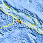
| Location | 9.056°S, 157.585°E |
| Depth | 18.7 km (11.6 miles) |
| Region | SOLOMON ISLANDS |
| Distances | 135 km (85 miles) SE of Gizo, New Georgia Islands, Solomon Isl. 195 km (120 miles) SW of Dadali, Santa Isabel, Solomon Islands 265 km (165 miles) W of HONIARA, Guadalcanal, Solomon Islands 2100 km (1300 miles) NNE of BRISBANE, Queensland, Australia |
| Location Uncertainty | horizontal +/- 7.5 km (4.7 miles); depth +/- 9.6 km (6.0 miles) |
| Parameters | NST=180, Nph=180, Dmin=263.3 km, Rmss=1.24 sec, Gp= 40°, M-type=centroid moment magnitude (Mw), Version=8 |
| Source |
|
| Event ID | us2010rca2 |
- This event has been reviewed by a seismologist.
- Did you feel it? Report shaking and damage at your location. You can also view a map displaying accumulated data from your report and others.
Earthquake Summary

 Tsunami Information
- NOAA West Coast & Alaska Tsunami Warning Center
- NOAA Pacific Tsunami Warning Center
- The earthquake locations and magnitudes cited in these NOAA tsunami bulletins are very preliminary and may be superceded by USGS locations and magnitudes computed using more extensive data sets.
- Tsunami Information Links
Earthquake Maps


Scientific & Technical Information

 Historic Moment Tensor Solutions
Additional Information, News Reports
- Preliminary Earthquake Report
- U.S. Geological Survey, National Earthquake Information Center:
World Data Center for Seismology, Denver
